municipality · Mayabeque
Bejucal
Bejucal est un(e) municipalité à Mayabeque, Cuba. Il se situe approximativement à 22.9328°, -82.3869°. Parmi les lieux cartographiés à proximité figurent Rosa Elena Simeó
Aperçu
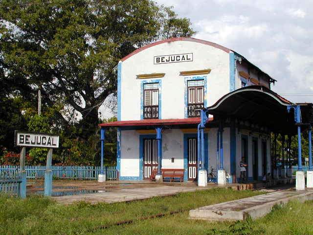
Bejucal is a municipality and town in the Mayabeque Province of Cuba. It was founded in 1713. It is well known as the terminal station of the first railroad built in Cuba and Latin America in 1837. It also hosts one of the most popular and traditional carnival fest in Cuba: "Charangas de Bejucal". Bejucal has also been known as a telecommunications site, hosting broadcasts of several news and media networks. It hosted Soviet nuclear warheads during the Cuban Missile Crisis. Bejucal is also believed to host a signals intelligence listening station operated by the People's Liberation Army.
Description from Wikipedia, licensed under CC BY-SA.
Bejucal est un(e) municipalité à Mayabeque, Cuba. Il se situe approximativement à 22.9328°, -82.3869°.
L'histoire de ce lieu
Y sont nés : Félix Pita Rodríguez, écrivain cubain (1909–1990), Fausto Ramón Mejía Vallejo, prêtre catholique cubain (n. 1941) et Yusnier Viera, mathématicien cubain (n. 1982).
À vol d'oiseau, le lieu se trouve à 53.6 km de sa capitale provinciale, à 20.2 km de La Havane et à 6.7 km de l'aéroport à vols réguliers le plus proche. Wikidata indique une superficie de 120 km², une altitude de 105 m.
Les lieux répertoriés les plus proches dans l'atlas sont Santa María (à 3.8 km au nord), Santiago de las Vegas (à 5.1 km au nord), La Salud (à 7.9 km au sud-ouest), Boyeros (à 8.4 km au nord), Wajay (à 8.9 km au nord-ouest) et Jardín botánico Nacional de Cuba (à 8.1 km au nord-est).
Points forts
Verified highlights
Source-backed classifications from the CubaAtlas record — each opens the places that share it. No star ratings.
Your companion for Bejucal
honest data · every value datedConditions
No dataLive weather conditions aren't connected here yet. When they are, this strip will summarize what's realistic to do today — and flag anything to check first — each value stamped with how fresh it is and where it came from.
Get there
22.93280, -82.38690Opens your maps app for turn-by-turn directions. CubaAtlas doesn't track your location.
Tropical outlook
LiveChecking the National Hurricane Center…
Weather
No dataAir temperature, wind, rain chance and UV for planning your day.
Weather adapters (NOAA + Cuba's INSMET) are the next feed to wire — each value will be stamped with its observation time and source.
Wildlife
LiveLoading recent wildlife records…
Daylight & season
Local time CDT (UTC−4). Computed from the date and coordinates — accurate to about a minute. Recent
Within the Atlantic hurricane season (Jun 1 – Nov 30). Check active advisories before coastal or boating plans.
Seismic activity
LiveChecking USGS for recent seismic activity…
Emergency
- 106Police (PNR)Recent
- 104Ambulance / medicalRecent
- 105FireRecent
- +53 7 866 4499Asistur (traveler assistance)Recent
State travel-assistance service for visitors (medical, legal, financial help).
These are Cuba's publicly published national numbers. Coverage, language support, and response times vary by area and are not verified in real time — confirm the correct local number with your accommodation on arrival.
CubaAtlas states how much it knows and how fresh it is. Values marked “No data” aren't connected yet — we show you the official source instead of guessing. Not for navigation, rescue, or legal decisions.
What's near Bejucal
Lieux à proximité
Distances are straight-line, measured between recorded coordinates — not driving distance.
Lieux cartographiés à proximité
Lieux nommés référencés dans OpenStreetMap aux alentours, du plus proche au plus lointain, avec leur distance.
Parmi les lieux cartographiés à proximité figurent Rosa Elena Simeón, El Sapo, Sede Universitaria Municipal Bejucal, Loma del Gobierno, Ciudad de los Niños, Maceo Gómez, Iglesia parroquial Santos Felipe y Santiago de Bejucal, Ciudad de los Niños, El rastro, Bejucal, Comunidad Científica, El Caguazo, Loma del Bigote, San Gabriel, Comunidad Río Hondo et Candelaria.
- Rosa Elena Simeón · memorial
- 0.2 km
- El Sapo · neighbourhood
- 0.3 km
- Sede Universitaria Municipal Bejucal · university
- 0.3 km
- Loma del Gobierno · peak
- 0.4 km
- Ciudad de los Niños · tower
- 0.5 km
- Maceo Gómez · park
- 0.5 km
- Iglesia parroquial Santos Felipe y Santiago de Bejucal · church
- 0.5 km
- Ciudad de los Niños · neighbourhood
- 0.7 km
- El rastro · works
- 0.8 km
- Bejucal · station
- 1.2 km
- Comunidad Científica · neighbourhood
- 1.5 km
- El Caguazo · hamlet
- 2.4 km
- Loma del Bigote · peak
- 3.6 km
- San Gabriel · hamlet
- 5.7 km
- Comunidad Río Hondo · village
- 8.6 km
- Candelaria · hamlet
- 9.9 km
Around Bejucal
1,347 named civic, cultural, natural and service places are mapped within about 15 km of Bejucal, across 32 categories. Open any category to see it on the map, centred on Bejucal.
Notable near Bejucal

Universidad de las Ciencias Informáticas (UCI)
Universities & colleges
The University of Informatic Sciences is a Cuban university research center based in the ward of Wajay, Boyeros municipal borough, Havana.

Jardín Botánico Nacional
Urban parks & plazas
El Jardín Botánico Nacional de Cuba es un jardín botánico de unas 500 hectáreas y en el que están expuestas unas 4 000 especies vegetales. Perteneciente a la Universidad de La Habana, tiene como objetivo promover el conocimiento en la población de los aspectos relacionados con las plantas, haciendo hincapié en la flora autóctona.
Al Coronel Juan Delgado
Historic & heritage
Juan Evangelista Delgado González was a Cuban colonel who participated during the Cuban War of Independence. He was known for retrieving the bodies of Antonio Maceo Grajales and Panchito Gómez Toro during the Battle of San Pedro where both were killed in the battle.
🏛️ Culture & heritage 98
🚬 Cuban craft & cuisine 5
⛰️ Nature & terrain 15
🌾 Farming & fishing 45
🏭 Industry & resources 113
🏥 Health & care 95
🎓 Education 185
🏦 Civic & services 244
🚉 Transport 25
🏟️ Sport & leisure 69
⛪ Faith 54
🛒 Shops & markets 162
🛏️ Stay 237
What Bejucal makes
152 working sites mapped — energy, industry, mining, farming, fishing and ports.The whole economy →
⚡ Energy 11
Batería Grupo Electrógeno · Batería Grupo Electrógeno Cuenca Sur · Batería Grupo Electrógeno CUJAE · Batería Grupo Electrógeno Fábrica de Oxígeno · …
🏭 Industry 105
Acopio · Acopio · Almacén · Almacén pesticidas · …
⛏️ Mining 1
Cantera Molinet
🌱 Farming 34
Finca Alcona · Granja Avícola · Granja Avícola Enrique Tejeda · Granja Quivicán · …
🐟 Fishing 1
Laguna de Crianza de Peces
Industrial heritage
2 pre-1959 sites in and around Bejucal — sugar centrales, railways, mines and ports.The 1959 heritage map →
- estacion Bejucalrailway
- Parque de Diversionesrailway
Official information and sources
generated from facts
- Wikidatageographic
- Wikimedia Commonsmedia